Underwater Tracking: How does it work?
Underwater tracking in simplistic terms is often referred to as underwater GPS. But it’s not quite the same. Does GPS work underwater? In short, no. The Global Positioning System (GPS) or broader term Global Navigation Satellite System (GNSS) works brilliantly through the air to understand where targets are, and how they’re moving. However, the moment you go beneath the water’s surface, GNSS isn’t any good. Why?
Simply, the radio frequency on which GNSS relies (1.2Ghz to 1.6Ghz), can’t penetrate water, and actually reflects off the surface. In order to have reliable underwater tracking, acoustics is the most commonly used method. At applied acoustics, we specialise in Ultra Short Baseline (USBL) technology, and operate in the medium frequency band (MF), typically from 16Khz up to 32Khz. This is the most common way to infer positioning subsea – whether that’s equipment, people, or points of interest.
How USBL systems operate
A USBL system consists of:
- a topside console or hardware interface;
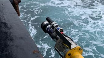
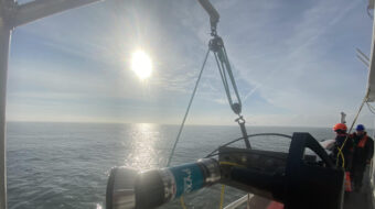
- a transceiver, mounted to a pole on a boat or other platform and extended down into the sea;
- a positioning beacon, located either on the seabed, ROV or towed array for positioning of targets such as underwater vehicles, towfish, structures and other applications.
How does a USBL system work?
An acoustic pulse is typically transmitted from the transceiver to the positioning beacon which then replies acoustically; the reply signal is received by the transceiver and displayed on the surface console or hardware interface.
The transceiver calculates the time between the first signal sent to the positioning beacon and its reply. The reply is received by multiple elements inside the transceiver head, which calculates the target’s range, bearing and depression angle using a least mean squares (LMS) algorithm, which is then passed to the surface console, and is displayed on the user interface. This allows the operator to locate where their targets are at a single glance.
The key advantage of a USBL over other types of subsea positioning (such as LBL arrays) is their convenience. They can be quickly deployed from the surface and there is no need for any additional equipment to be deployed subsea. The only exception is that each target must be fitted with a compatible acoustic positioning beacon.
To maximise positioning repeatability and accuracy, we always recommend the use of our proprietary Sigma digital protocols. The digital signal spread across the frequency band allows for a more robust signal reception and improved timing and range stability, increasing the repeatability of results.
Other external sensors can be interfaced into the navigation system such as an inertial measurement unit (IMU), a Gyro and target parameters, such as depth, or in the case of vehicle tracking, heading. This can often be sent up serially, over a network, or with the right hardware, acoustically and used by the USBL system to improve the position accuracy.
How can you interface GNSS to a USBL?
Standard practice is to input the ship’s GNSS into a USBL system, allowing the positioning data to be converted to absolute positions by the USBL system.
This process takes into account all the aforementioned sensors and data that can be interfaced to the system. However, setting up and calibrating these sensors and GNSS input takes time. Consequently, it’s important to perform a calibration to maximise accuracy.
Because of this complexity, a USBL system is best suited to long-term installations or longer-duration survey operations, such as DP reference positioning, diver support, ROV operations and towed surveys.
What’s the alternative?
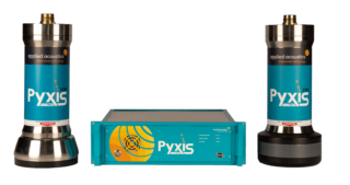
A combined USBL and INS (inertial navigation system) system such as the Pyxis INS + USBL has closely coupled inertial sensors to the acoustics and GNSS antenna connected to the USBL system. This allows for precise and accurate alignment of the GNSS to the acoustics for real time corrections for the changing movement of the vessel.
Other than an alignment of the GNSS antenna to the transceiver, the system is calibration- free. This makes it ideal for quick mobilisation onboard vessels of opportunity, and for accurate and repeatable positioning on vessels that do not have the capability of high accuracy survey grade Gyros and IMUs.
This all-in-one package enables the operator to begin working immediately from any vessel, saving operational time and money.
Do divers have GNSS?
As anyone who’s gone diving with a mobile phone will know, the GNSS signal becomes very weak or disappears completely as water obstructs the radio waves. This means divers are unable to use standard GNSS devices to communicate underwater.
Positioning of divers is sometimes challenging, as divers typically operate in or around structures. In some applications, a GNSS can be deployed on a buoy above the diver and connected by a wire that enables the diver to navigate underwater, with the GNSS position being sent to an underwater monitor.
Our range of MiniPod submersible GNSS receivers can be used for this application. Combined with a small battery pack the diver’s position can be accurately sent to the diver and wirelessly sent back to the vessel/ dive team for monitoring.
Where this is not possible, such as commercial dive operations, diver positions can be generated by using a small acoustic positioning beacon attached to the diver and a USBL system. This allows the ship to keep track of the divers’ positions, improving subsea safety and allowing the dive operators to provide divers with instructions for subsea navigation.
Our range of underwater tracking equipment
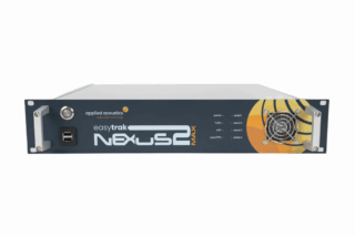
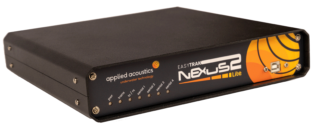
Easytrak USBL Systems: are available in a range of specifications to suit the size, depth, range, and number of targets that need to be positioned. Their advantages include:
- Ability to track multiple targets at the same time
- Compatible with aae acoustic release and positioning beacons
- Ability to track shallow water targets as well as targets operating in deeper waters
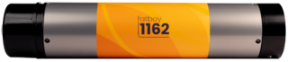
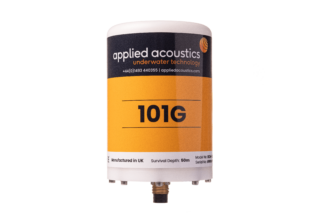
Positioning Beacons: our positioning beacons can cover a wide range of applications, from short-range dives and towed arrays to vehicle tracking in deep water and challenging environments. Stable, with a rugged construction, they are compatible with the majority of industry-standard tracking systems.
Underwater tracking devices – case study
Learn how Ocean Scan utilised the aae Easytrak Nexus 2 USBL and Mini Beacons to accurately position their assets to identify shipwrecks, debris and other underwater hazards.